Introduction
At this place no comprehensive guide to extract map material from the internet, only some indulgences. There are lot of programs for copying the content of a window or a whole screen to the clipboard. Look for yourself an chose one that suits you best or where you are familiar with. Such a program, however, is not necessary, but can make life easier. Windows itself is offering some possibilities. The button combination ALT + Print screen will copy the content of the active window on the clipboard. The Print screen button copies the contents of the entire screen on the clipboard. In a graphics program you can copy the content form the clipboard into a image or you can open it as a new image. Some websites copying the window or the screen with the cursor om it. Be aware, test it and keep it in mind. When copying, you may want to use the F11 button of your browser (Internet Explorer®, Firefox®, Opera®). This button maximizes the size of your browser window without the ballast of the navigation bar at the top of the window and details at the bottom. The last tip in this section is the button combination ALT + TAB. This combination allows you to switch between the opened applications; for example between your browser, your graphics program and possibly your file-manager.
And more
In your graphics program, you can use the available tools to crop the image (mainly to cut the edges). If one image is sufficient for your map, then you are actually ready. Just make sure that in every corner of the map a well recognizable point is that you can use later to the calibration of the map. Would you build your map with multiple images make sure these images overlap. Also, make sure, that you have multiple recognizable points in the overlap area. Try to find combinations of horizontal, vertical and diagonal lines. By laying these points exact over each other you can stitch the images together. You can use these later for calibrating the map.
Resolution
When grabbing map material form the internet, it is important to determine the right map scale and resolution (pixels per inch). Read my note "Relationship between scale and resolution of a map". From my own experience I know that a resolution of 100 pixels per cm (or 254 pixel per inch) suits best.
Color depth
The modern graphics cards are set by default to 16,000,000 colors (this is a color depth of 24 bit). This is the best setting. Only when all the work is done the color depth should be reduced to 256 colors (8 bit). Most navigation programs work with this color depth. Of course you can experiment your graphics card to by setting it to 256 colors, but then the graphics program that you use to stitch work, must also coped with this color depth.
Window size versus screen size
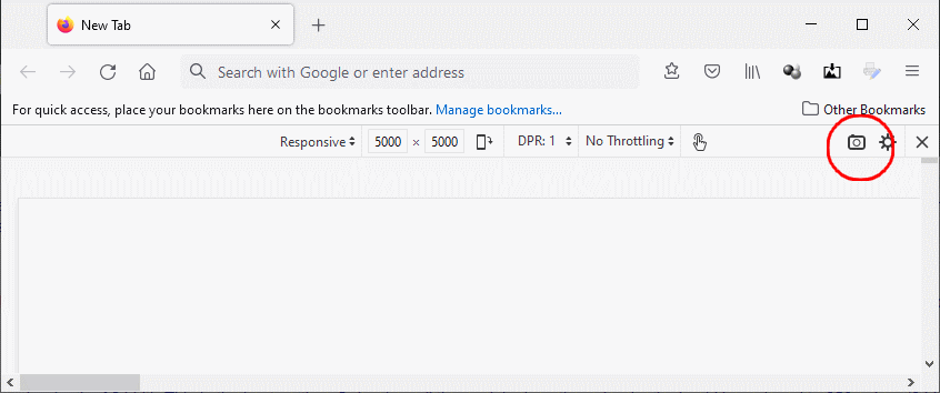
Most people think the screen wide is the maximum width of window. That is not always the truth, especially if you are using Firefox. In Firefox the size of a window can be extended by using the Responsive Design view (options > More tools > Responsive Design mode, or the button combination CTRL + SHIFT + M) to any height and width (figure 5000 x 5000 pixels). This Design view has also an option (the camera button) to save the content of your window to a graphic-file (in the full extent).
PDF-files
In some cases, map material is made available in as PDF-files. These files are usable but must first be converted to the TIFF, JPG or PNG format. To do this, use a PDF Viewer with an export function.
Last updated Augsut 10. 2021