Calibration with self chosen reference points
If you have only a section of a map sheet (may be scanned by yourself) or extracted some material from the internet, the calibration process is more complicated. You have to search for reference points yourself. In this case there are three options. with ascending workload these are:
- Reference points which geographical coordinates in latitude and longitude are known,
- Reference points which geographical coordinates are known in another coordinate system and
- Reference points which you chose yourself and determining the coordinates using an other program or map.
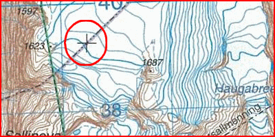
Option 1: On many maps there are markers for latitude and longitude, for example every geographical 5 minutes. Below, a part of a Norwegian map (self scanned). With figuring out the latitude and longitude of three or four of these markers and the map datum you are able to calibrate the map.
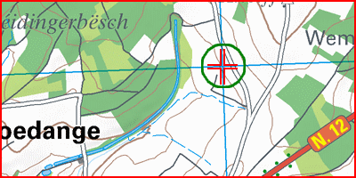
Option 2: Many maps come with a coordinate reference system. This makes it possible to determine coordinates of the reference points (based in the coordinate system of the map). Using a conversion program you can convert these coordinate to latitude and longitude. Below an example of a map of Luxembourg. On the internet you can find a great variety of conversion programs. Some examples: tools-online.com, gpscoordinaten.nl (Dutch maps) and twcc.fr.
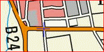
Option 3: Here you determine the reference points
and there coordinates yourself. It Is important to select the reference
points good and sharp on both the map you calibrate and the (online-)map
that you use to determine the coordinates. Look for square crossroads.
If the roads on the map several pixels wide, then choose the middle of
the roads (see image below). If necessary, zoom in for a more accurate
result. ArcGIS
is a good option for determinate the coordinates. Some alternatives are
Google
Earth Pro (change the setting for coordinates in decimal degrees
(additional > options > 3D view > lat/long)) or twcc.fr.
After complication of the calibration process you can add more information to to the JPR-file, see JPR-file and Additional information